


Descrição do Surveyor
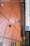
With Surveyor, you can measure distances by placing markers on a virtual ground that is overlaid on the camera image.
Surveyor locks the virtual ground to the real world so no matter which direction you turn to, the markers will always stay where it is originally placed.
Distances between each markers are calculated and displayed on the screen in the unit system you specified. With the pro version you can place more than 2 markers and even get the area of the space surrounded by the markers.
</div> <div jsname="WJz9Hc" style="display:none">Com Surveyor, você pode medir distâncias, colocando marcadores em um terreno virtual que está cobrindo a imagem da câmera.
Surveyor bloqueia o terreno virtual para o mundo real por isso não importa qual direção você recorrer, os marcadores de sempre ficar onde é colocado originalmente.
Distâncias entre cada marcadores são calculados e exibidos na tela do sistema de unidade que você especificou. Com a versão Pro, você pode colocar mais de dois marcadores e até mesmo obter a área do espaço cercado pelos marcadores.</div> <div class="show-more-end">
Surveyor - Versão 2.5.2
(14-02-2013)Surveyor - Informações do APK
Versão do APK: 2.5.2Pacote: com.miian.android.surveyorApps na mesma categoria
Você também poderá gostar...


